Mobile GIS data collection apps with Leaflet and PostGIS

  • Overview
  • Curriculum
  • Instructor
  • Review

About This Course

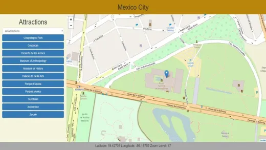
Use your phone as a GPS data collection device with no users fees or subscriptions

Learn how to develop your own HTML5 GPS data collection applications that work like a native app on your mobile device.  While there are many canned options available for mobile data collection that may meet your needs, there are many times when it may be more cost-effective to develop your own.

  1. Cost - Even if your needs are simple many commercial applications require monthly per-user subscriptions, often in the neighborhood of $30-$50 per month. For 1 or 2 users that may not be much but with 50 users it quickly becomes cost effective to write your own.

  2. Customizability - Commercial "non-programming" solutions tend to be one-size fits all. Although they may have some flexibility, it is not uncommon for many applications to need functionality that is not available.  Writing your own mean that if you can envision it you can implement it. Often you can implement it faster than you could in a "non-programming" solution even if it is available.

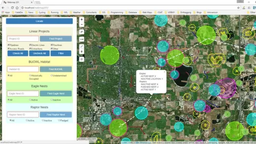
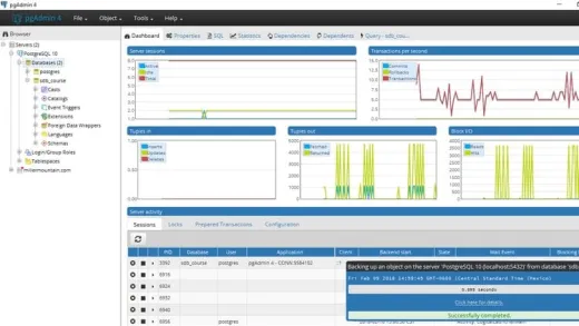
  3. Real-time data access - The techniques taught in this course access a PostGIS database directly so that any changes that are made are available immediately to any other client applications whether they be desktop GIS like ArcGIS or QGIS, other web applications, or other client software such as a spreadsheet program, etc.  This also means that there is no time wasted transferring data from device to server, etc which may save hundreds or even thousands of man hours in large data gathering efforts and avoid a large source of errors.

HTML5 web applications also have some downsides for this type of work and these are discussed in the course and potential solutions are also addressed.

  • Develop your own custom mobile data collection applications that are limited only by your imagination and don't require expensive user fees or subscriptions.

Course Curriculum

Instructor

Profile photo of Michael Miller
Michael Miller

I have been programming and working with database applications for over 30 years, and specializing in geospatial applications for over 20 years.  I am a believer in the 80/20 pareto principle which suggests that you only need to understand 20% of a subject in order to do 80% of your work. My goal in all my courses is to teach...

Review
4.9 course rating
4K ratings
ui-avatar of Bokamoso Lawrence Maoto
Bokamoso L. M.
5.0
1 year ago

It's a perfect match. I am an Environmentalist specialising in GIS. Data collection is a norm to me, it will be great to be able to design databases for Apps specific to my needs.

  • Helpful
  • Not helpful
ui-avatar of Claude Mushid
Claude M.
5.0
1 year ago

Excellent and fantastic course! So helpful!

  • Helpful
  • Not helpful
ui-avatar of Winston Sevilla
Winston S.
5.0
2 years ago

This course gives me a better background on how I can implement GIS on future projects that might come in. Being a Software Engineer, this will help me to implement with lesser learning curve. I'm happy with how the author discuss all the topics and have an actual demo on each sections. Thank you for this wonderful information that I learn. Some of your courses are still in my library queue and hoping to expect the same vibes as I go over on this course. :)

  • Helpful
  • Not helpful
ui-avatar of Vladislav Roshcheniuk
Vladislav R.
4.5
2 years ago

Very nice course to start develop a Geo App

  • Helpful
  • Not helpful
ui-avatar of Falowo Saleem Oluwafemi
Falowo S. O.
5.0
2 years ago

Good presentation

  • Helpful
  • Not helpful
ui-avatar of Gul Afzal
Gul A.
5.0
2 years ago

Very great efforts by instructor to create such a good course by combining different technologies to bring a great solution. highly appreciated.

  • Helpful
  • Not helpful
ui-avatar of Philipp Nelis
Philipp N.
3.0
2 years ago

Very good course until almost the end. Last lesson is still missing, no final project code is shared. Will change my rating to a 5 star rating when the instructor finishes the course and provides the code of the finished project.

  • Helpful
  • Not helpful
ui-avatar of Daniela Bonilla
Daniela B.
5.0
3 years ago

aprendĂ­ cosas nuevas.

  • Helpful
  • Not helpful
ui-avatar of GIS Simplified
Gis S.
3.0
3 years ago

First of all:
- Instructor is having in-depth knowledge on the subject and he is able to transfer the knowledge to the student.
- Clear communication and to the point explanation.

Giving three stars because:
- In the last lecture # 66, instructor says, we will learn committing offline changes to database in the next lecture. But there is no next lecture.
- Instructor is required to share final complete project code with "All and Only" supporting resources (js, css, php and other files, without including junk files which were not discussed during the training)
- there are two buttons in the feature list screen. Refresh and Download. Existing training does not cover those two buttons.

Instructor may consider addressing these three points and I may revise rating to 5 star.

  • Helpful
  • Not helpful
ui-avatar of Celso Ruiz
Celso R.
5.0
3 years ago

Great!!!

  • Helpful
  • Not helpful
Leave A Reply

Your email address will not be published. Required fields are marked *

Ratings

Courses You May Like

Lorem ipsum dolor sit amet elit
Show More Courses